Amager Øst is one of ten districts of the city of Copenhagen, Denmark. The island of Amager is home to a couple of such districts, the suburb of Kastrup, some more communities, the airport of Copenhagen, and the westward end of the Drogden Tunnel. The Northern and Western parts of Copenhagen lie on the much larger island of Sjælland (Zealand).
Pre-Rash History[]
Amager Øst was originally named Sundbyøster, after a 11th century village, and Dutch crafts- and boatsmen were permitted to settle there by the Danish crown. Industrialization of the area peaked in 1870, then actual industries were phased out until in 1980, business activity was dominated by trade and services.
The North of Amager was made a part of Copenhagen Municipality in 1902, an urban refurbishment program (Byfornyelse) was started in 1997, and an administrative reform that ran from 2006 to 2008 brought the change of the district's name to Amager Øst.
By Year 0, Amager Øst was not only a lively district of Copenhagen with important shopping streets, but also home to the attractions of Amager Strandpark and the Holmbladsgade Sports and Culture Centre.
Post-Rash History[]
In spite of the supply dock (see below) probably located at the artificial island of Prøvesten, and thus in Amager Øst, we currently do not have any information about the district's fate between the Years 0 and 90.
Our protagonists, said to have proceeded further than the Danish land reclamation efforts ever got even before entering Kastrup, have entered Amager Øst either advancing towards or escaping from "spot 24".
Points of Interest[]
"Spot 24"[]
- For the main page on this topic, see Amager Spot 24.
"Spot 24" was the first location that the expedition investigated to salvage books, and is believed to be in Amager Øst. About twenty books (of limited value) could be collected before the team got into a fight with monsters and had to retreat.
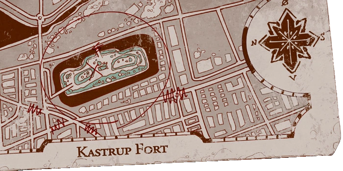
Kastrup Fortet[]
The fort of Kastrup is the safe place the expedition went to after leaving "Spot 24". It is located on Amagers East shore, approximately halfway between the airport and the Southernmost installations of the Copenhagen harbor (namely, the island of Prøvesten).
Pre-Rash History[]

The "fort" was actually a battery of the second defense line of the naval and coastal fortifications of Copenhagen. It consists of two bunkers surrounded by a ~25 m wide moat, said to be 2-3 m deep and filled with sweet water, about 300 m from the actual coast. The bunkers originally housed artillery as well as smaller, MG-style calibers. Ongoing developments in weaponry and battle doctrine made the fortifications outdated soon after their construction, if not even before they were finalized.


In year 0, the fortifications of Copenhagen were historic monuments and attractions. Kastrup Fortet was accessible by one bridge at its North end that allowed cars, and a pedestrian bridge installed in the center of its East side, between the two bunkers. Next to the latter, a glass-walls-only building set between the bunkers housed the Restaurant Kastrup Fortet. On the Southwest corner of the "island", a playground (and possibly picknick area?) had been installed.
Post-Rash History[]


The expedition retreated to the fort after getting into combat with monsters at "Spot 24". According to Lallis findings, transcribed to the map by Tuuri, the pedestrian bridge has turned unusable and the cat-tank's position should be directly to the South of the Northern bunker, out of sight of any monster approaching the remaining bridge.
The Supply Dock[]


The supply dock with its partially destroyed lighthouse on the tip's circular platform
After the mixup leaving the expedition without rations has finally been detected, Trond blackmails the captain of the Icelandic ship Túnfiskurinn into delivering new crates to them. The meeting point is a pier with a - largely crumbled - lighthouse on the platform that forms its tip. According to Trond, it has been built "during the Danish reclamation attempt![]() " - probably the same that ended with the Great Defeat of Kastrup, around year 80.
" - probably the same that ended with the Great Defeat of Kastrup, around year 80.
No information on its exact location is given, but during the approach, the ruins of various industrial tanks line the road. This suggests that the post-Rash Danes constructed it off the edge of Prøvesten (![]() "touchstone"), an artificial island that grew out of one of Copenhagens naval forts into the outer harbor of the city that it was in year 0 and was, in turn, connected to Amager by means of the street running over a short dam.
"touchstone"), an artificial island that grew out of one of Copenhagens naval forts into the outer harbor of the city that it was in year 0 and was, in turn, connected to Amager by means of the street running over a short dam.
The map on arc 1 page 375![]() shows the cat-tank's planned itinerary on what likely is the second day after the meeting with the Túnfiskurinn, and the starting point is positively Prøvesten, lending further support to the theory that that's where the pier is located.
shows the cat-tank's planned itinerary on what likely is the second day after the meeting with the Túnfiskurinn, and the starting point is positively Prøvesten, lending further support to the theory that that's where the pier is located.